COASTAL UNSTRUCTURED RESOLUTION FOR AQUATIC ENVIRONMENTS
PI and organization: A. Sanchez-Arcilla (UPC),
Co-Is: M. Espino (UPC), M. Mestres (UPC), D. Gonzales-Marco (UPC), J. Schulz-Stellenfleth (HZG), Johannes-Pein (HZG) J. Staneva (HZG), L. Boye Hansen (DHI-GRAs), S. Huber (DHI-GRAs), M. Olander Rasmussen (DHI-GRAs)
Abstract: The main objective of CURAE is to prepare a new set of downscaling and coupling tools which, based on present CMEMS products, will open a wide range of coastal applications and contribute to enhance the coastal dimension in CMEMS. The core of the project is the incorporation of the coastal fringe as an active boundary layer, interacting bi-directionally with the shelf sea and including the continental discharge in terms of water, sediment and nutrient fluxes. To prove the feasibility of this approach two coastal pilots have been selected that feature river and irrigation discharges, dredging and their interactions. The selected sites also represent two contrasting environments (micro and macro tidal, low to high wave energy, mild though point wise torrential and medium to high precipitation rates) and two different numerical approaches for downscaling so that the derived conclusions and tools should be generic enough and of direct value for a CMEMS extension towards the coast. Such a general aim and structure will be developed along five main axis of work: 1) incorporating into CMEMS 3D land discharges from rivers and distributed continental run off (Tasks 1 and 2); 2) including hydro-morphodynamic interactions to make explicit the role of morphodynamic control (inlet mouth bars regulating land discharge, beach erosion and breaching regulating overwash) from CMEMS products (Task 2); 3) promoting the use of unstructured grids in CMEMS, benefitting from the higher flexibility for distributing mesh nodes (Tasks 1 and 3); 4) introducing asymmetric interpolation and error assessment techniques as required by anisotropic coastal domains (Tasks 2 and 3); 5) assessing the different relative weights of processes and coupling in coastal areas, with respect to deep water oceanography, providing criteria and recommendationsfor the further evolution of CMEMS (Task 3); 6) proving the feasibility of including some selected coastal interventions (controlled irrigation discharges or dredging) into the CMEMS based forecasting tools, to illustrate another coastal extension with high added value for specific applications and general land/water planning. This will lead to specific proposals for coordinating Coastal Observatories (two pilots) with CMEMS Data Centres, providing new datasets for CMEMS and, in particular, for further exploitation of Sentinel data. These results will be disseminated (Task 4) mainly to CMEMS, to support its short to medium term development, in a coordinated approach with other longer term more scientific oriented projects, facilitating the transfer into CMEMS architecture and practice.
Project highlight at mid-term:
Modelled (red) and measured (blue) surface current components inside Fangar Bay (Ebro Delta, NE Spain) for October, 2017. The CURAE 3-domain nested scheme was forced either by CMEMS-IBI (left) or CMEMS-MED (right).
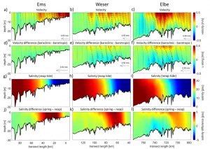
Long term mean circulation and salinity distribution along the thalweg of the Ems (left), Weser (centre) and Elbe (right) estuaries. Top row, mean velocity; second row, difference between mean velocities in two different scenarios; third row, salinity during neap phase; bottom row, difference between spring mean and neap mean salinity.


