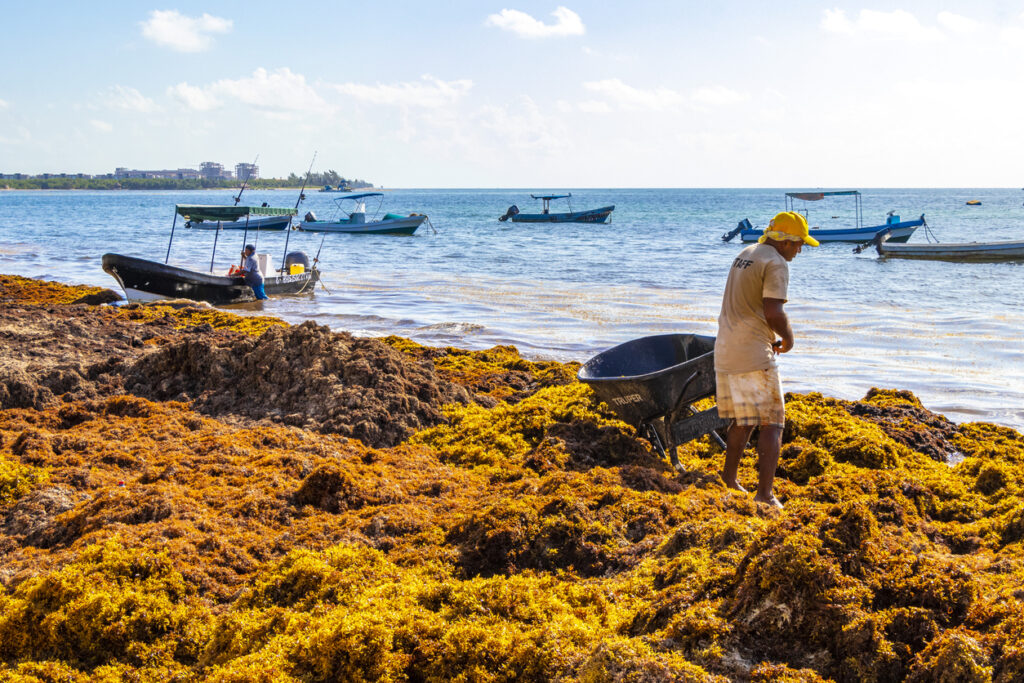
Since 2011, large quantities of Sargassum algae have been stranding on Caribbean beaches causing significant socio-economic and environmental issues, negatively affecting the livelihoods of local communities. A technical paper recently published in the scientific journal Geoscientific Model Development (GMD) investigates new regional high-resolution Ocean forecasting system for Sargassum algae drift and accumulation called CAR36 (Caribbean ARchipelago system at 1/36° of resolution). The paper, co-authored by a team of Mercator Ocean International (MOi) scientists and external oceanographers, comes as Oi seeks to improve modelling capabilities used by the French meteorological forecasting service Météo-France to forecast Sargassum drift in the Caribbean region.
Why Sargassum Algae is a Major Issue
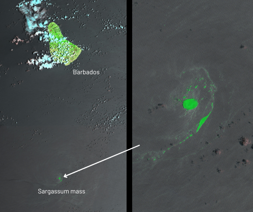
Sargassum is a type of macroalgae (seaweed) proliferating in the open sea as well as in nearshore waters and coral reefs. While originally concentrating in the Sargasso Sea (a region in the North Atlantic Ocean, bounded by four currents forming an Ocean gyre), Sargassum has shown since 2011 exponential growth along a band extending from the West African coast to the Gulf of Mexico, known as the Great Atlantic Sargassum Belt.
Sargassum masses have been causing major socio-economic, environmental and health problems in the Gulf of Mexico, the Caribbean Sea and the tropical Atlantic. The large influxes of Sargassum impacts directly maritime traffic, and thus transport and fisheries activities. Once stranded on the seashore, Sargassum decays and releases smelly gas which disrupt recreational use of the ocean and can cause respiratory problems. Inundations of Sargassum also harm some of the richest coastal and marine ecosystems.
It is therefore important to develop reliable forecasts of Sargassum drift that can support local communities to adopt pre-emptive actions and minimise the negative impacts of Sargassum beaching. The proliferation of the Sargassum algae is of concern to international and national bodies, including the United Nations’ (UN) Intergovernmental Oceanographic Commission (IOC/UNESCO), its subcommission for the Caribbean and Adjacent Regions (IOCARIBE) and the UN Environment programme’s Regional Sea Conventions of Cartagena under the Protocol Concerning Specially Protected Areas and Wildlife for the Wider Caribbean Region (SPAW).
MOi contributes to addressing this challenge by supporting the Sargassum drift forecasting development but also by promoting the coordination of global experts to answer the needs of IOCARIBE and SPAW through the GEO Blue Planet action.
The New CAR36 System Shows Promising Results
The recently released study CAR36, A Regional High-Resolution Ocean Forecasting System For Improving Drift and Beaching of Sargassum in the Caribbean Archipelago led by MOi Experts presents a comparative analysis of forecasts generated using GLO12 and CAR36 over the year 2019.
GLO12 is a global Ocean analysis and forecasting system operated by Mercator Ocean for the Copernicus Marine Service. GLO12 integrates satellite and in situ observations to produce comprehensive global Ocean data, including temperature, salinity, sea surface height, currents and sea ice thickness, fraction and velocities. This system supports a variety of applications such as marine conservation efforts, Ocean pollution, blue economy activities and much more.
However, GLO12 provides too low resolution to accurately reproduce detailed flow patterns that can affect Sargassum drift and beaching. Mercator Ocean has therefore developed CAR36, a “local refinement” of GLO12 designed to offer higher spatial resolution (i.e. approximately 3 km in the area of interest) and data on tides and atmospheric changes at a higher frequency.
Researchers found that CAR36 better matched observed ocean conditions, particularly in predicting the movement and evolution of ocean eddies (circular currents of water). These eddies are important in the overall Ocean observation process in the Caribbean region, as they influence where Sargassum algae will drift.
On the other hand, the authors underline that the results presented in the paper cannot be considered final, and should be complemented by statistical assessments and additional observations in the region, particularly the study of a larger sample of eddies on an extended period.
Collaborative Efforts in Monitoring and Predicting Sargassum Drift
The development of CAR36 emerges in the context of MOi’s commitment to providing Météo-France, one of its shareholders, with sub-surface current data over the Caribbean archipelago region to feed into the Météo-France Sargassum drift forecasting system.
MOi is actively involved in other regional and global efforts to monitor floating sargassum, contributing to effective mitigation and adaptation strategies. These include:
- the FOREcasting seasonal Sargassum Events in the Atlantic (FORESEA) initiative, led by the French Research Institute for Sustainable Development (IRD, one of MOi’s shareholders), initiated to provide forecast maps over the equatorial Atlantic Ocean for mid-term and large-scale forecasting of Sargassum drift. This seasonal forecasting system will be made fully operational by MOi in the framework of a SCO project (Space Climate Observatory) initiated by the French Space Agency (CNES) in collaboration with Collecte Localisations Satellites (CLS), IRD and MOi.
- MOi hosts the EU Office of the GEO Blue Planet initiative, the Ocean and coastal arm of the Group on Earth Observations (GEO). GEO Blue Planet hosts a Sargassum Working Group, identified as the expertise group by IOCARIBE and the SPAW. This initiative leverages collaboration with international and regional partners to bridge the gap between data and societal needs to deliver actionable information. The working group is currently developing the Sargassum Information Hub that serves as a single point of access to knowledge on Sargassum. EU actions within GEO Blue Planet are deployed through EU4OceanObs, an EU-funded project implemented by MOi with the goal of strengthening international partnerships for Ocean observations.
Additional Resources
- Read the paper “CAR36, a regional high-resolution ocean forecasting system for improving drift and beaching of Sargassum in the Caribbean archipelago”
- Visit the GEO Blue Planet website and Sargassum Information Hub
- Learn more about the FORESEA initiative
- Learn more about the Global Ocean Physics Analysis and Forecast GLO12
- Learn about the Sargassum Operational Detection Algorithms (SODA) project, one of fourteen R&D projects funded by the Copernicus Marine Service to support future service evolutions
- Discover the EU4OceanObs Earth Observation value chain case study on Sargassum