COASTAL UNSTRUCTURED RESOLUTION FOR AQUATIC ENVIRONMENTS
PI and organization: A. Sanchez-Arcilla (UPC),
Co-Is: M. Espino (UPC), M. Mestres (UPC), D. Gonzales-Marco (UPC), J. Schulz-Stellenfleth (HZG), Johannes-Pein (HZG) J. Staneva (HZG), L. Boye Hansen (DHI-GRAs), S. Huber (DHI-GRAs), M. Olander Rasmussen (DHI-GRAs)
Coastal areas, featuring a high level of complexity and dynamics, evolve at a variety of scales due to a combination of coastal interventions and natural processes, such as wave storms or river floods for operational prediction scales. Coastal domains host specific physical processes that are not adequately reproduced by basin or self -scale models, often as not missing the meso and sub-meso scale processes responsible for the gradients that characterise coastal seas. This results in an incomplete description by present numerical systems (both off-line and operational), which present errors largely exceeding those for deeper or more open waters. However, coastal zones support a high concentration of infrastructure and socio economic activities, requiring an accuracy and robustness not commonly found in many present applications. Without such improvements, the unprecedented wealth of data and knowledge offered by CMEMS will not be directly applicable to solve the large variety of problems associated to the sustainable exploitation of coastal resources, illustrated by conflicting sun tourism and port operations, water quality for aquaculture and bathing, etc.
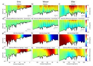
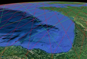
CURAE aims to fulfil this need by proposing a generic and coherent approach to downscale Copernicus Marine products for high resolution operational modelling of coastal areas, taking into account the active nature of the coastal boundary. This downscaling has been demonstrated by two applications, the first for a Mediterranean deltaic bay (Fangar Bay, in the Ebro Delta, Spain, shown in figure 1) and the second for a set of estuaries in the North Sea (German Bight system of estuaries, Germany, shown in figure 2). The two cases represent two contrasting and dynamic sites with complementary metocean conditions and a variety of environmental issues that would greatly benefit from an anticipated prediction.
The main steps of the CURAE project can be summarised by the following points:
- Implementation of coupled hydro-morphodynamic suites at each of the studied sites, using structured and unstructured grids to address the efficient downscaling of coastal processes and the incorporation of freshwater land discharges.
- Operational data and dynamic error propagation analysis, leading to a coastally adapted system with direct error quantification for hydrodynamic and derived variables, and using Sentinel-derived data to update domain bathymetry and coastline in a continuous but efficient manner.
- Development of a generic methodology for consistent interfacing (nesting, downscaling and transformed variables) between large scale, structured CMEMS models and the coastal models and downstream applications of CURAE.
- Preparation of a set of criteria to extend CMEMS products towards the active coastal fringe, addressing the CMEMS requirements for boundary conditions, driving terms and derived fields. This will entail a dynamic definition of the coastal fringe as an active boundary for CMEMS shelf and open sea predictions.
The project results include the development of a robust approach for downscaling CMEMS products (model and satellite data), within a framework for high-resolution modelling of coastal areas. Such an approach includes the flexible interfaces required for coupling coastal models to regional products of different types. These tools are developed for both structured and unstructured grid models, and will underpin the wider use of unstructured grids in CMEMS, benefitting from the higher flexibility for distributing mesh nodes. CURAE also promotes the inclusion of 3D freshwater outflow and a regular bathymetry/coastline updating within the models. These advances will allow correctly accounting for density and morphological interactions with local and regional hydrodynamics.
CURAE contributes to pave the way for a coastal core extension of CMEMS. CURAE’s outcome is of particular importance to support this CMEMS coastal extension considering local domain features and gradients, as well as a more complete set of non-linear coastal processes that are currently limiting predictability. This quest for improved predictions is a repeated requirement by coastal stakeholders, in dire need of more reliable predictions for currents, waves, levels and water quality. The achieved improvements in forecasting and derived indicators will support a more sustainable management of co-existing coastal activities (e.g., aquaculture, dredging), based on downscaling tools that are easily exportable to other coastal areas.
Figure 1. Schematization of the Mediterranean test case, showing the modelled (red) and measured (blue) surface current components inside Fangar Bay (Ebro Delta, NE Spain) for October, 2017. The 3-domain, nested, CURAE scheme was forced by CMEMS-IBI (left) or CMEMS-MED (right).
Figure 2. Schematization of the North Sea test case, showing the long term mean circulation and salinity distribution along the thalweg of the Ems (left), Weser (centre) and Elbe (right) estuaries in the German Bight. Top row, mean velocity; second row, difference between mean velocities in two different scenarios; third row, salinity during neap phase; bottom row, difference between spring mean and neap mean salinity.


